
The First New Zealand Lithographs
R. P. HARGREAVES
In their pioneering work Early Prints of New Zealand, E.M. and D.G. Ellis award the palm for the first print to be lithographed in New Zealand to Robert Park's Village of Richmond, which they note was probably printed in 1842.1 They specifically reject a claim by Dr T.M. Hocken that a print he had collected, and which is now in the Hocken library, Dunedin, was the first.
The latter print, Lambton Harbour & Mount Victoria from Tinakore was drawn by W. Mein Smith, and printed and published by 'Jones & Bluett Lithog. Wellington, New Zealand', but bears no date.
The Ellises' comments about this print are as follows:
At the time Mein Smith arrived in Wellington there was only one press, and that not capable of printing lithographs ... Mein Smith's Lambton Harbour was published by ]ones and Bluett, and the publication date was thought by Hocken to be 1839-40. The first record of a Bluett in Wellington is 11341, when Thomas and Adam Bluett arrived in the Olympus. It is known that by 1842, in Hobart, Tasmania, the lithographic firm of Thomas Bluett was in operation, and in the author's opinion it is more likely that Mein Smith's view was drawn in 1839, but printed in Hobart in 1842.
W. Mein Smith, who had been a professor at the Royal Military College at Woolwich before becoming Surveyor-General for the New Zealand Company,2 was, like most early surveyors, a competent topographical artist as well. As Mein Smith did not arrive in Wellington until early January 1840, his sketch of Lambton Harbour & Mount Victoria from Tinakore could not have been made in 1839 as suggested in Early Prints of New Zealand ' nor published in that year as proposed in part by Hocken.
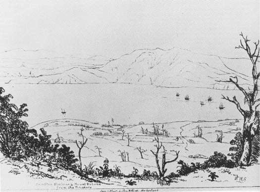
WILLIAM MEIN SMITH
Lambton Harbour
& Mount Victoria
from the Tinakore
lithograph, 190 x 255mm.
(collection of
The Hocken Library)
In 1841 at least, Smith lived in what he called 'Tinakore Cottage': so the view was one very familiar to the author, and was possibly the one he saw from his own residence .3
The first reference to Mein Smith's sketch of Lambton Harbour appears in the N.Z. Gazette & Wellington Spectator of 12 June 1841. Jones and Bluett's lithographic view was described as a mere sketch, but it would be interesting to our friends at home; we hope, therefore we shall be allowed to have it on sale at a small price. We esteem it, because it is in every respect faithful, and must tend to give the absent a right conception of the harbour and its scenery.
A fortnight later the view was advertused as being available from the 'Gazette Office' for two shillings each, and its availability continued to be noted over the next two months. Thus Smith's view of Lambton Harbour undoubtedly predates the sketch of the Village of Richmond.
This view, however, was only a secondary production of Jones and Bluett. What they had recognised as being of primary significance was a chart of Port Nicholson harbour, along with maps of the surveyed sections of Wellington. These were necessary for the growth of the settlement, whereas the lithographed view was only an extra.
And so the first lithographic work undertaken in New Zealand was in fact a chart of Port Nicholson. The only known copy of this is also housed in the Hocken Library, Dunedin.
The chart was the result of survey work in September 1839 by Edward Main Chaffers - an experienced nautical surveyor then employed by the New Zealand Company.
A copy of the manuscript chart had been taken in Wellington before the original had been sent to the New Zealand Company in London, at the end of 1839 or early 1840. Plans to have the chart reproduced in New Zealand by means of a woodcut came to naught when the copy was allegedly lost.4
With the arrival of Thomas Bluett in 1841, the chart could now be lithographed. On 27 May 1841 the first chart or map to be printed in New Zealand was put on sale at 2s 6d a copy. The chart is thought to have been copied from the English edition first published in London by James Wyld on 1 June 1840.5
Many copies of the chart were bought by interested Wellington parties and distributed gratis to ships' masters. By mid-June, for example, it was reported that 'a large number had been forwarded to Akaroa and other places, with instructions to put them on board of whaling and her vessels not acquainted with our port'.6 It was thus hoped to make the port more popular, and help dispel rumours of its dangers.
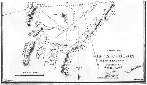
Detail of the
chart of Port Nicholson
(lower half)
(collection of
The Hocken Library)
Other maps followed the Port Nicholson chart. One of 'Wade's town' was noted as having been published in early June 1841:7 but an advertisement for plans of Wellington which appeared in the N.Z. Gazette & Wellington Spectator of 16 July 1841 was cancelled the following week, owing to Jones and Bluett finding it necessary to construct 'a new press, with which to print them, the press with which they were commenced proving inadequate to the work'.
The construction was apparently achieved, as on 21 August 1841 the Plans of Wellington were advertised as being available - large size, coloured 10s 6d; large size, plain 5s.; and small size plain 2s 6d. These maps have not been sighted.
Jones and Bluett also attempted to produce a lithographed newspaper, but the Victoria Times only appeared once: on 15 September 1841.8 A Plan of the City of Wellington Port Nicholson New Zealand which appeared as part of the Victoria Times is possibly a further printing of the small plan referred to above.
The later history of Jacob Jones and Thomas Bluett is not known: but the T. Bluett who the Ellises' noted as being a lithographer in Hobart, Tasmania, in 1842, could well have been the Wellington lithographer of the previous year. From an advertisement in the N.Z. Gazette & Wellington Spectator (13 November 1841) it appears that relations had deteriorated between Jones and Bluett. The former cautioned the public against giving credit to T. Bluett, lithographer Printer, on account of an alleged partnership which he represents has existed or does exist between him and myself, such partnership never having had any existence.
Bluett never responded to this warning - at least in public - and this is the last reference we have to J.W. Jones and T. Bluett. But despite their short existence in Wellington, they can still claim the honour of printing and publishing the first lithographed view and map in New Zealand.
1. E.M. & D.G. Ellis, Early Prints of New Zealand 1642-1875, Christchurch, Avon Fine Prints, 1978: 87-88.
2. F.W. Furkert, Early New Zealand Engineers, Wellington, Reed, 1953: 269.
3. N.Z. Gazette & Wellington Spectator, 6 October 1841: 4.
4. N.Z. Gazette & Wellington Spectator, 16 May 1840: 2, 12 September 1840: 2.
5. The history of this chart is discussed more fully in R.P. Hargreaves, 'Chaffers' Chart of Port Nicholson', N.Z. Geographer, Vol. 21 Oct. 1965: 170-173.
6. N.Z. Gazette & Wellington Spectator, 12 June 1841: 3.
7. N.Z. Gazette & Wellington Spectator, 12 June 1841: 3.
8. G.11. Scholefield, Newspapers in New Zealand, Wellington, Reed, 1958: 27.